 Live Music Archive
 Librivox Free Audio
 Metropolitan Museum
 Cleveland Museum of Art
 Internet Arcade
 Console Living Room
 Books to Borrow
 Open Library
 TV News
 Understanding 9/11
tv [untitled] January 26, 2013 3:00pm-3:30pm PST

3:03 pm
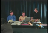
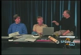
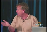
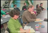
>> good afternoon. i'm the chief building inspector with the department building inspection. welcome to our brown bag lunch series. this is the regular third thursday of every month event. we are finishing up with a talk about the outside lambs, an area that was previously considered uninhabitable. uninhabitable due to fog. [inaudible]
3:04 pm
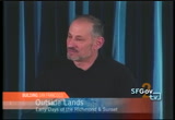
but we have with us a couple of real experts in outside plans. -- i am outside -- in outside lands. woody has devoted a lot of his time and effort to the outside lands. >> we are a nonprofit in our 10th year, and we are dedicated to preserving and sharing the history of san francisco. >> it is great to have you here. and pat, who has a lot of knowledge and brought to be sure today a lot of [inaudible] , and she can share with that -- she can share that with us as well, and we only regret that harvey the wonder dog could not be here. we talked about [inaudible] what area, generally, are we
3:05 pm
talking about? >> the term came from what was called the pueblo land when the san francisco peninsula was switched over from mexican ownership to american ownership. certain tracts were preserved, so there was a more orderly, even though it took decades, transfer of ownership of those lands, but there were also what were called pueblo lands, which were sort of a poem by the town, and then, there was a whole lot of discussion about what should happen to those -- which were sort of zero and -- sort of owned by the town. >> so was san francisco's bordered upon at the time, or did that happen later?
3:06 pm
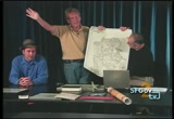
>> san mateo county did not exist when they originally chartered it. i think there were 16 counties, and a few years later, they said they were too large, so they doubled back and created san mateo county. >> this is an early map of an area that might have been known as san francisco, but it did not have a defined southern boundary yet. >> the city i believe was up larkin street, and everything west was counties. i think larkin was here. that is the original charter. then in 1850, van ness, who was the supervisor, did the addition. it was called the western addition, even though it was in the middle of the city, because it was west of larkin. >> i did not understand that
3:07 pm
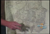
when i was a child. it always seemed that it was east of where everything i knew was. >> all this down here was county of san francisco, so there was a point in time where you could be in the county of san francisco, but not in the city you live in these outside lands. >> lead problem is if you look at the orientation, no. is up. we are going to turn it the way we are normally accustomed to seeing it. here is where the golden gate bridge is. here is where the bay bridge is. the county went all the way down here, and about a year later, they moved the county to write about here, so this was county land or outside land, and this was the city. this was 1861, so the city has grown by this much.
3:08 pm
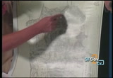
these were added, and they are basically pasture lands. that is where petrero street is. >> and out here, the rancho -- what is a rancho? >> it is a mexican land grant that we agreed to respect when we still california from the mexicans. we agreed to respect the land grants that existed, and there was a commission set up. regretfully, none of the land grants were legally bested, so most of them were taken away from the mexicans. the other portion were pureblo lands, which would be considered entitled to four square leaks -- leagues. so 30 square miles with the
3:09 pm

possession of the pueblo of san francisco for public use, and that is how we got golden gate. when they acquired it as publicly, part of the treaty said you had to all mexican law, which set a certain amount of outside plants must be used for schools, playgrounds, open space. the original chaldea san francisco -- the original county of san francisco came from san mateo county. they decided it was too large a county, said the card off another county. at the time, the largest population in the state was in san francisco. l.a. barely made a presidio. they had, like, 50 or 60 people. 90% of the population was in san francisco, and everyone down the peninsula is saying if they are in the county, san francisco has this huge population, we are
3:10 pm
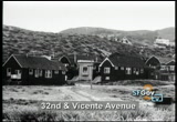
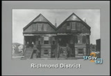
going to have to go along with them, so they can't get off -- they carved it off. >> it looks like it is the richmond district, but a kind of shows what was on the west side town. a great deal of it was sam, and for that reason, people thought that the weather and the san -- it was really not a place that people wanted to live, and it was going to be very typical for san francisco -- very difficult for san francisco to expand west. >> if you look at the early maps, it was 3 miles wide by about 6 miles long, this huge sand dunes that just moved around. >> here is an 1875 map of the laguna. says along the side of the map, high sand hills between the pacific ocean and the like. by the way, this had actually
3:11 pm
opened directly into the ocean. >> lake merced had a high water level. since we paid over much of the city, the water levels have dropped, but at one time, the late actually trade out into the ocean approximately where the dog diner is that now. somewhere in the 1870's, they saw the damage at the water in the late so it did not exit out uncontrolled, and for 10 years, people were drinking lake merced water as drinking water. it is much bigger, too. if you go to san francisco state, the practice will appeal this part of the lake. i do daily city, that was part of the lake. it was huge. >> the southern area [inaudible]
3:12 pm
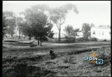
but there is a different area. >> there was a creek that came down basically through west portal and said that particular lake. >> that was filled in when they develop west portal, and they had the brilliant idea when they dug but,, they needed a place to put it, so they build the creek in with the tunnel muck. >> you can see in 1910, we are talking about after the earthquake, but outer richmond is still pretty sparsely settled. >> or anyone who ever wondered what richmond is named after, it was a guy by the name of marsh, who was from richmond, england. >> australia? >> australia? >> george turner marsh. >> no trees at all. people see trees in the city and think they may have been made.
3:13 pm

sand and scrub. at some point, these are the lives were used recreational -- these outer lands were used recreational lly. . >> there is. we hoave -- what, the third? >> depends on it you are coming the addition. but they all burned down. that was around 1900, so if you are ever stuck in traffic in the six-lane boulevard in 19th avenue, imagine what it was like back then. >> [inaudible] i would say this is after they began to develop some homesteading entries. >> it was a large chicken ranch out there. lawson chicken ranch was along
3:14 pm
19th ave. >> [inaudible] >> not exactly. he donated the land later to the city, though. sort of the farm house feeling of the richmond. >> there is a water tower with a windmill in the back. >> right, get your water from wells. that was the early boathouses. looking at that map, sporting men would come out in the horses, have little races with their horses and carriages and the sea horse races, maybe get in a card game, have a drink of the way to the beach. >> but this was when there was county land, so there was no gambling. the move people out to county for the race track. >> they were away from intense public scrutiny out there. >> my of the state is there were four racetracks in the city. -- my understanding.
3:15 pm
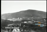
can you name them? >> pioneer, union, in the side, and oceanside. >> there ago. maybe there are more. >> we have a big article on race tracks on our website. outsidelands.org. >> the ingleside, you can still see that. >> they developed where that race track was, just south of ocean avenue, they kept the oval of the race track and created urbano drive. >> i think we have some progress of that. >> that is the inner sunset. that is where >> lawrence lives > i do. >> you can see the inner sandbank. it is a big old sand hill. they had to do a lot of grading.
3:16 pm
>> in the building department, when we go out and look to people to building development, as soon as they squared away the top 6 inches or whatever is there, it is all sand. forever. in my yard, and there is nothing you can do about it. it is what there is. it was generally developed in response to the 1890's for mid- winter there, which was held in golden gate park. would the first buildings that was built in that area was a bar called the little shamrock, and it is still there just west of lincoln, just west from ninth avenue. it was built to help service people who were working on the big winter fair. they are still hoping the neighborhood. >> it is an offshoot of the 1892-8093 columbian exposition
3:17 pm
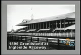
in chicago. when they were done, san francisco said bring it here. >> that is the chicken ranch. the building to the east of that is the chicken ranch, and you can see beyond to the west all sand dunes and hollows and gullies. that is one of the row houses we were talking about. as late as 1910, there were crackdowns and vice raids [laughter] >> that is a good way to say it. >> that is the racetrack grandstand. >> that is huge. >> opening day in 1895 through 14,000 people. they put a train line to it. they had a street car line. it was a big deal in those days, horse racing was.
3:18 pm
>> reason really interesting progress about car bill. tell us about what cargo was. >> in 1895, adolph sutro owned a couple blocks of land, which were sand dunes. the pavement, the streets. south of golden gate park. there was a train line that brought people from downtown to the beaches. mostly, it was used on sundays. it went along with a good way to the beach. top of that, a few people started using old horse carts, which are essentially street cars that were pulled by horses. they became obsolete as cable cars and electric trolleys took over. and they took these old horse cars and made little foot houses out of it -- clubhouses out of them. some of those turned into permanent residences, and you had up to 100 of these little cars all tumbled out there in the sand dunes. >> i remember when i was a kid
3:19 pm
going out there, some of them with all the way over to the zoo, and they had taken more modern streetcars and made holds out of them by picking them up and putting him on a sandlot. >> after the 1906 earthquake, they put in a lot of electric car lights, so it just kept growing. >> here is a building incorporating cars. >> in the upper story. st. andrew's church. 47th ave. a lot of artists and writers and people you might call bohemians at the time went to cargill. it was an artistic place to hang out. you have people going out, maybe getting into landscape, maybe just partying. >> but wasn't there some push back? it had an unsavory reputation. >> in 1913, the lead was
3:20 pm

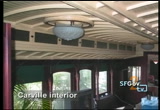
settled, and it was supposed to be sold, and a lot of people did not like it because they thought there was a lot of romantic rendezvous happening there that perhaps should not be. they had a ceremony there to burn the car out of cargo, so they have a big bonfire. it was the fourth of july, so they threw some fireworks in, too, and they were trying to announce that it was a new neighborhood. it was respectable. that is essentially the last and best carville house on the highway. two cable cars that are joined together. they took out the walls and connected the rope and of course, as a bedroom. and i would like to buy it. >> i think we have a photograph of the inside of one of these cars. >> yes, some of the original cable car bridges are still on the inside. it is a wonderful place. i'm writing a book on carville. that is ucsf.
3:21 pm
adolph sutro donated the land. >> he had a lot of land. >> did. he bought a rancho in '82, and it was a huge chunk of land in a little peninsula. it took decades for it to fill in with housing. >> when he died, he leapt 1,100 acres to widows and orphans, and his children that truck. they comprise the woods, sherwood forest, forestville. it was a contentious thing. it took about 13, 15 years in public. >> this is actually in golden gate park, the casino. it was a controversy at the time to have a place that serve liquor and had card games in golden gate park. eventually, it moved to 24th ave. >> we still have the newly recently refurbished stop along
3:22 pm

the great highway. the beach shall i -- chalet. i always find it ironic that these federal highway funds were used to refurbish this place for drivers to get a drink. terrific. [laughter] >> there were farms, and there were dairies, as these houses are starting to be built, and they are more conventional residents is, and they are still a farm. in the distance, you can see it is still sand dunes. >> and water once again from windmills and wells. >> there is a few small lakes. some of the lakes are natural lakes. they are not all man-made. >> it took a while to get the water lines out there. >> you can see the huge sand dune behind it. it was a challenge to get basic services.
3:23 pm
people would build houses, and instantly, a huge sand banks would blow in the night and basically close-up people's front doors. they had a lot of development that was needed before they could make a nice place to live. >> this was the park side real estate brochures from about 1913. >> 1908. >> there are pages you can read. inside it shows what you can do. it was so might be developed but never got develop. >> the realty company was going to take all of it and essentially the lead in and put houses in there. that was their plan. it was a very nice square grid. so the south side of the sunset is called the park side. i think it would be closer to golden gate park, but it was sort of a realty bargaining scheme because it was mostly sand dunes. the first announcement was that it was much warmer than you
3:24 pm
would imagine. it is beautiful. there are trees. you could get away from the wind. it is sunny. they were just trying to make it sound good. >> there was a row house down there -- there is still a row house down there. >> you could rent that for your wedding. the boss of san francisco, who was dethroned after the earthquake, he was arrested. they tracked it down there. he was hiding out. >> was it still county land at that time? >> city lead. >> this is after it was subdivided into standard lots? >> they are big. anyone who live there, you might have a backyard twice as long as your house. smaller home builders started taking root with larger ones.
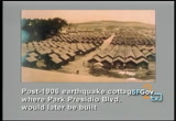
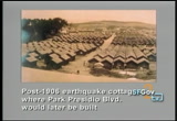
3:25 pm
a lot of times, it was like this. a guy would buy a couple of lots and essentially build two houses and tried to sell them. or live in one. they did that all the way up to the 1940's. one of the last parcels a friend of mine lived on on 28 and cabrilla, which used to be a garbage dump, and in the 1940's, they build it over with sand -- they have lots of that lying around. >> this is parker studio boulevard in the richmond district. you are on the road, which is this piece of land. after the 1906 earthquake and fire, there were a refugee camps for and in a lot of the refugee camps, there were earthquake refugee cottages. these were small little portable cottages built on these camps, and the idea was you could live there, and when the camps closed after a bad year, you could take it away to an empty lot.
3:26 pm
>> you had to buy it. >> you could, but your rent would go towards the purchase price. by the end, they just wanted to get rid of them. >> in 1930, all of these were declared a substandard structures and the city wanted them all destroyed because they were blights. >> but there still are many. how many are left? >> there is at least 30. >> out of 5610 built. >> yes, sir. >> i just love to do find out what the orientation of this picture is. part presidio would have run pretty much right through there? >> right. this is reserve as city land for a park. people were really excited because they were just about to start doing some landscaping of the park, and then the earthquake hit, and they said no park.
3:27 pm
there were going to put thousands of refugees there. the neighbors complained about it until they realized they could sell goods, services, anything to these refugees, and they made a lot of money, so they were ok with it. >> [inaudible] boulevard existing now, or did it come in after this? >> there was no boulevard. it came in in the teens. this was the sunnyside, just northeast of city college. another early land scheme, and this is a point you were making, that streetcars were in a very important factor in getting the west side settled. so he built the first electric streetcar in san francisco, and he conveniently had to go right to a bunch of land he owned where he created the sunnyside, which was a suburb. you take the streetcar out to the suburbs. >> outside a town was the way it
3:28 pm

was described. not that far. >> far enough. and it was not sunday, either. >> again, it is all marketing. >> i'm looking at the names of streets. who got to name the streets in these new sñ what is interestins alphabetical on the sunny side. acadia. it is alphabetical. it ended at hamburg. in world war room in one, people did not like it. they thought it was -- world war i, people did not like it. they thought it was too german. >> there are two in bayview hunters. . there is one that treasure island then there is one out there.
3:29 pm
-- there are two in bayview hunters poitn. -- point. >> they said, we will rename all of the streets. they decided to name them after spanish explorers, which was controversial. they compromised. some of the streets are named after an indian place in yosemite. >> they had the number of streets already put in, nice and simple. they wanted to name the other ones, and they wanted to name all of the east-west one's with explorers -- ones with explorers.
89 Views
IN COLLECTIONS
SFGTV2: San Francisco Government Television Television Archive
  Television Archive News Search Service
Uploaded by TV Archive on
